PANNON LAKE AND VOLCANISM
Geodynamics
The structure of the Earth is layered like an onion. Pieces of its outer solid layer (plates of the continents) „float” on the liquefied asthenosphere that is part of the mantle under it, and like drift-ice on a river, they accumulate and roll up somewhere and draw away from each other elsewhere. Our area is actually located in the hundreds of kilometres long collision zone of the Eurasian and the African plates, thus the geological processes are determined by the Alpine mountain formation. In the collision zone, accordingly in the vicinity of the Pannonian Basin, the movement of many smaller microplates makes the geohistoric reconstruction harder.
The Pannonian Basin was formed since the Early Miocene by the significant elongation and depression of the Earth’s crust. Its base consists of two microplates, the (northern) ALCAPA, which broke away from the edge of Africa, and the (southern) Tisza-Dácia element, which came from the edge of the Eurasian plate. In the Miocene, the plate fragments moved primarily in eastern direction, while the ALCAPA moved counter clockwise, the Tisza-Dácia element rotated clockwise. Part of the edge of the Eurasian plate, the origin of which is mostly oceanic, later dived under (subduction) these microplates, bended back, and a huge chunk of it broke down and started to sink back into the liquefied mantle. As a result of the rotational and pulling forces aroused during this process, the bottom of the basin thinned away and sank, and until today choked up with various sediments which somewhere reach a thickness of 6000 metres.
In the area of Hungary, the thickness of the Earth’s crust is only 23‒27 km, elsewhere the continental crust is 30‒50 km and the oceanic crust is 5‒10 km thick.
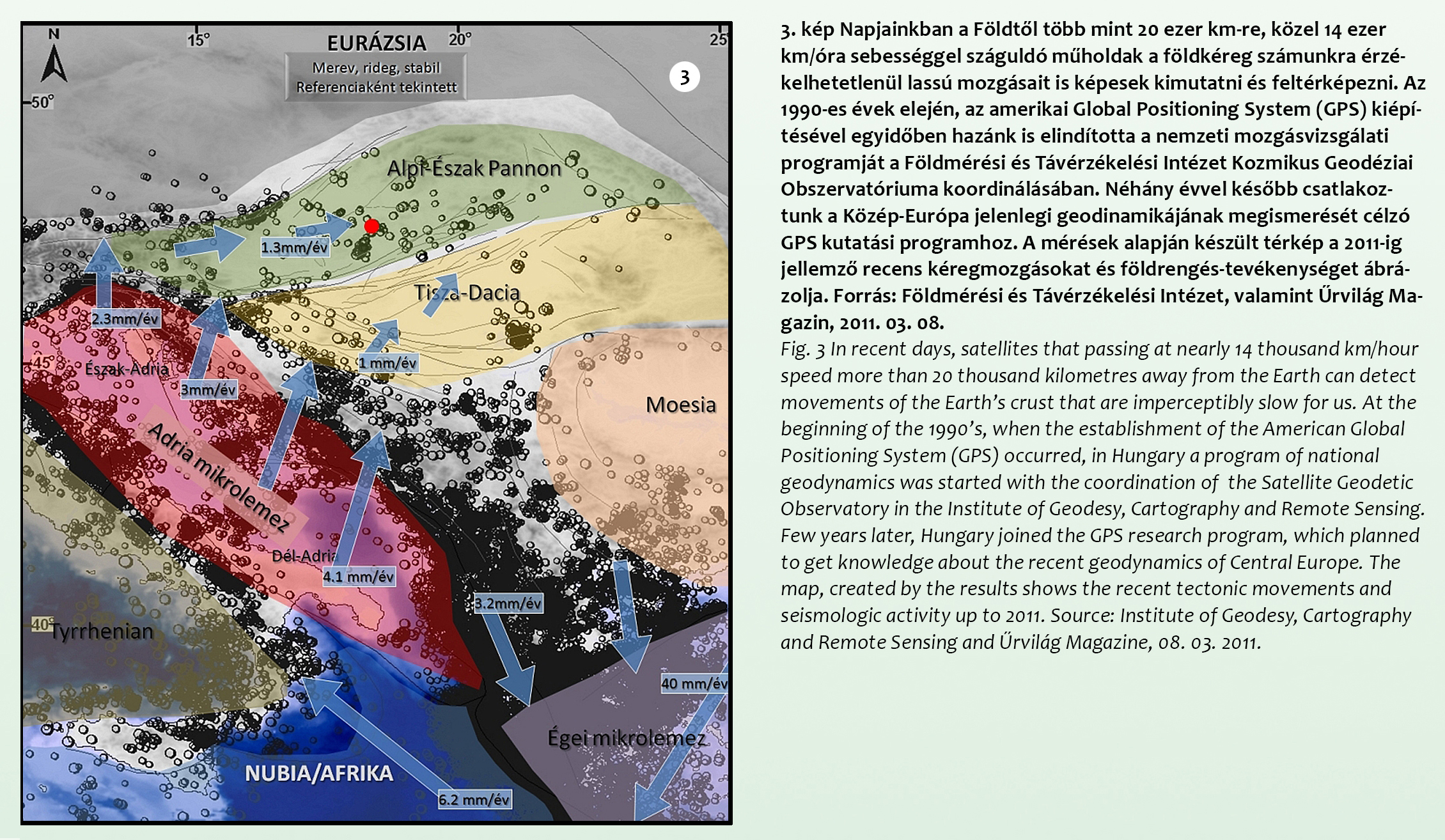
Fig. 3 In recent days, satellites that passing at nearly 14 thousand km/hour speed more than 20 thousand kilometres away from the Earth can detect movements of the Earth’s crust that are imperceptibly slow for us. At the beginning of the 1990’s, when the establishment of the American Global Positioning System (GPS) occurred, in Hungary a program of national geodynamics was started with the coordination of the Satellite Geodetic Observatory in the Institute of Geodesy, Cartography and Remote Sensing. Few years later, Hungary joined the GPS research program, which planned to get knowledge about the recent geodynamics of Central Europe. The map, created by the results shows the recent tectonic movements and seismologic activity up to 2011. Source: Institute of Geodesy, Cartography and Remote Sensing and Űrvilág Magazine, 08. 03. 2011.